
Excerpted from St. John Off The Beaten Track
Caneel Hill Ascent
The Caneel Hill Trail begins in Cruz Bay about twenty yards past the Mongoose Junction parking lot and rises to the summit of Caneel Hill. The trail then descends, running along the ridgeline to the saddle, or low point, between Caneel Hill and the next mountain peak, Margaret Hill. From the saddle the trail leads to the top of Margaret Hill and then descends down the opposite face of the mountain and arriving at the North Shore Road (Route 20) just across from the entrance to the Caneel Bay Resort.
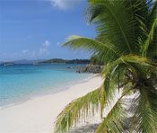
The trail to the peak of Caneel Hill is a steep and steady incline, gaining 719 feet of elevation in less than one mile. The view from the summit, however, is spectacular and well worth the fairly arduous climb to get there. Bring some refreshments, enjoy the cool breeze from the summit, and plan to stay a while to savor this unique mountaintop.
 The Caneel Hill Trail passes through dry forest terrain in an area once dedicated to the cultivation of cotton. In the late nineteenth century the cotton plantations were sold or abandoned, and the land was then used primarily for pasture and for the cultivation of small provision garden plots until its acquisition by the Virgin Islands National Park in the 1950s.
About a third of the way up the trail (0.3 mile) you will come to the intersection of the Caneel Hill Spur Trail, which will be to the left and leads downhill, crosses the North Shore Road, and then continues on to meet the Lind Point Trail. The trail to Caneel Hill is to the right and uphill.
A bench near the top of the trail will provide a welcome location to stop and rest and enjoy northerly views that are as goods as or better than can be seen on the summit.
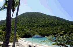
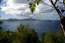
At the peak of Caneel Hill you will be treated to a magnificent panorama. In 1995, Hurricane Marilyn destroyed the wooden viewing platform, but there is still a bench where you can sit and rest at the end of this strenuous climb. From this vantage point you can see a great deal of the Virgin Island archipelago and on clear days you may even be able to see as far as the mountainous El Yunque rainforest on Puerto Rico more than 40 miles west.
 From Caneel Hill to the Tamarind Tree
From the summit of Caneel Hill the trail continues to the east and leads to the top of Margaret Hill. You will first make a rather steep descent down the eastern side of Caneel Hill. The guinea grass-lined track follows the southern side of the ridge between the two mountain peaks, and provides an excellent vantage point from which you can enjoy spectacular views of the southwestern side of St. John.
The trail then crosses the crest of the ridge and runs along the northern side of the mountain opening up some views of the island's north shore and beyond.
The path continues to descend until it reaches the saddle (lowest point on the ridge) between Caneel and Margaret Hills where there is a large and ancient tamarind tree under which the National Park provides a rustic bench. This is an excellent place to stop for a rest and take advantage of the well-placed bench and the cooling the shade of this magnificent tree.
From the Tamarind Tree the trail rises up to the summit of Margaret Hill and then descends to the North Shore Road at the entrance to the Caneel Bay Resort. [The Tamarind Tree sits on the property line between Caneel Trailside Cottage and Virgin Islands National Park].
Caneel Trailside Cottage is a strictly non-smoking property.